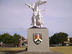
| Magelang | |
|---|---|
| Scenery of Magelang | |
| Motto: HARAPAN | |
| | |
| Coordinates: 7°28′0″S 110°13′0″E / 7.466667°S 110.216667°E | |
| Country | Indonesia |
| Province | Central Java |
| Regency | Magelang Regency |
| Government | |
| - Mayor | H Fahriyanto[1] |
| Area | |
| - Total | 18.12 km2 (7 sq mi) |
| Elevation | 350 m (1,148 ft) |
| Population (2003) | |
| - Total | 120,000 |
| - Density | 6.623/km2 (17.2/sq mi) |
| Time zone | WIB (UTC+7) |
| Area code(s) | +62293 |
| Website | www.magelangkota.go.id |
Magelang is one of the largest cities of the 1,130 km² Magelang Regency, Central Java, Indonesia. It is also the largest town in the Kedu Plain between Mount Merbabu and Mount Sumbing in Central Java, Indonesia. Magelang is located 43 km north from Yogyakarta, and 75 km south of Semarang, the capital of Central Java[2].
Magelang has two official residency government, Magelang Resident and Magelang City.
Contents[hide] |
[edit] Landscape of Magelang City
Magelang City is a small city which is located in a fertile agricultural area and one of the most densely populated regions on Central Java. Magelang City has two borders. Its western border is Progo river; its eastern border is Elo river. The city is divided into three districts and several subdistricts. [3].
Magelang Utara (North Magelang):
- Kramat Utara
- Kramat Selatan
- Kedungsari
- Wates
- Potrobangsan
Magelang Tengah (Central Magelang):
- Magelang
- Cacaban
- Kemirirejo
- Gelangan
- Panjang
- Rejowinangun Utara
Magelang Selatan (South Magelang):
- Tidar Utara
- Tidar Selatan
- Rejowinangun Selatan
- Magersari
- Jurangombo Utara
- Jurangombo Selatan


Tidak ada komentar:
Posting Komentar